


Severe cyclonic storm Murasu is very likely to cross the southern coast of Andhra Pradesh, in south-eastern India, between Nellore and Narsapur and to the south of Ongole, from 23:30 India time on 2 November 2026 to 04:00 on 3 November, with maximum sustained winds of 100 to 110 km/h gusting to 120 km/h, according to the India Meteorological Department (IMD), which has issued a cyclone warning with a red message. Murasu is due about six days after Arnab, which crossed the coast near Narsapur on 28 October, and as the ripening and harvest of the monsoon-season rice crop begins in southern India according to the GEOGLAM crop calendar. If it comes ashore as a severe cyclonic storm, it will be the first time in IMD best-track records going back to 1996 that two cyclones of that strength have crossed the Andhra Pradesh coast between October and December of the same year, according to a Wikifarmer analysis.
IMD expects Murasu to cross the coast south of Ongole on the night of 2 November
In IMD's National Bulletin No. 14, issued at 14:30 India time on 2 November, Murasu was centred at 11:30 over the west-central Bay of Bengal near 14.2°N 81.1°E, about 120 km east-southeast of Nellore, 180 km southeast of Ongole and 170 km northeast of Chennai, and was moving west-northwestwards at 14 km/h. IMD says it is very likely to move northwestwards and cross the southern coast of the state as a severe cyclonic storm on the night of 2 to 3 November, between 18:00 and 22:30 UTC on 2 November. The forecast table in the same bulletin has it weakening into a cyclonic storm with winds of 80 to 90 km/h by 05:30 on 3 November, into a deep depression by 23:30 that day and into a depression by 11:30 on 4 November, near 17.1°N 79.0°E over Telangana. The warning covers Andhra Pradesh and the adjoining north Tamil Nadu coast, and the system is being tracked by the Doppler weather radars at Chennai, Machilipatnam and Visakhapatnam.
The Global Disaster Alert and Coordination System (GDACS), run with the European Commission's Joint Research Centre, has Murasu on red alert, with a maximum wind speed of 120 km/h and an estimated 2.104 million people in the zone of category 1 winds or stronger. GDACS wind speeds come from a different method from IMD's, so the two values are not directly comparable.
Heavy to extremely heavy rain is forecast over Andhra Pradesh and Telangana
In its press release of 2 November, issued at 13:00 India time, IMD says heavy to very heavy rain is very likely over coastal Andhra Pradesh, Rayalaseema and Telangana on 2 and 3 November, and that isolated extremely heavy rain is also likely over coastal Andhra Pradesh and Rayalaseema on 2 and 3 November and over Telangana on 3 November. National Bulletin No. 14 forecasts light to moderate rain at most places over coastal Andhra Pradesh, heavy to very heavy rain at a few places and extremely heavy rain at isolated places on 2 and 3 November, and heavy rain at isolated places on 4 November, with the same picture for Rayalaseema on 2 and 3 November.
In the forecast of the European Centre for Medium-Range Weather Forecasts (ECMWF) run at 00:00 UTC on 2 November, the heaviest rain over the three days from 2 to 4 November falls around Guntur and the Krishna river upstream of Vijayawada, with 360.6 mm at the grid point near Bapatla, 298.1 mm near Guntur, 145.8 mm near Machilipatnam and 143.1 mm near Ongole, while the grid point near Nellore gets 75.7 mm. The highest value in the area between 13.5°N and 17.5°N and 79°E and 82.5°E is 578.6 mm, at 16.50°N 80.00°E, about 70 km west of Vijayawada, and 26 of the area's 255 grid points, over land and sea, exceed 200 mm. The forecast has changed a lot from run to run. For the same three days, the grid point at 16.75°N 82.25°E, south of Kakinada in the Godavari delta, fell from 247.3 mm in the 29 October run to 63.0 mm in the 30 October run and to 28.1 mm in the 2 November run, while the 30 October run already put more rain to the southwest, around Bapatla and Guntur.
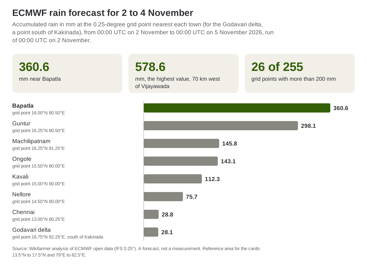
Source: Wikifarmer analysis of ECMWF open data (IFS 0.25°), run of 00:00 UTC on 2 November 2026. A forecast, not a measurement.
A storm surge is likely to flood low-lying areas of the southern coast
According to National Bulletin No. 14, a storm surge of more than 0.5 m above the astronomical tide is likely to inundate low-lying areas of the southern Andhra Pradesh coast from the evening of 2 November to the morning of 3 November, peaking at 1.0 to 1.5 m during the night, with the maximum over Bapatla, Krishna and Prakasam districts. National Bulletin No. 13, based on observations at 08:30 the same day, and the 13:00 press release also said that a surge of about 1.5 to 2.0 m is very likely to inundate low-lying areas at the time of landfall, a figure Bulletin No. 14 does not repeat. For the state's coast and the districts the bulletin names (Krishna, Bapatla, Prakasam, Nellore, Guntur, Eluru, NTR, Palnadu and West Godavari), winds are likely to reach 80 to 90 km/h from the afternoon of 2 November and 100 to 110 km/h, gusting to 120 km/h, during the night until the early morning of 3 November, then to ease after landfall to 40 to 50 km/h by the evening of 3 November.
IMD warns of major damage to standing crops and orchards
Among the expected impacts for coastal Andhra Pradesh, National Bulletins No. 13 and 14 list for agriculture major damage to standing and coastal crops, plantations and orchards, falling of green coconuts and tearing of palm fronds, and major damage to banana, papaya and drumstick trees, while the secondary hazards include riverine and coastal flooding. These are the impacts IMD associates with the storm's strength, not recorded damage.
In the agromet advice of its press release, IMD advises farmers in coastal Andhra Pradesh to provide adequate drainage in paddy, groundnut, cotton, red gram, sugarcane, maize, vegetable, banana and papaya fields to prevent waterlogging. It advises lifting lodged rice and vegetable plants after the rain subsides, raising and tying lodged sugarcane, protecting produce that has already been harvested and holding back the sowing of rabi crops such as maize and pulses until soil moisture is right, while banana and papaya need mechanical support. For Telangana, IMD advises postponing the harvest of mature rice, maize, cotton, fruit and vegetables and moving harvested produce to safe places.
Kharif rice ripening and harvest begin on 1 November in southern India according to GEOGLAM
In the GEOGLAM crop calendar for southern India, kharif rice, the monsoon-season crop, completes its vegetative and reproductive phase on 31 October, while ripening and rice harvesting run from 1 November to 14 December and the end of the harvest to 14 January. On the same calendar, planting and early growth of the dry-season (rabi) rice also start on 1 November and run to 14 January. Murasu is therefore expected to reach the coast in the first days of the ripening and harvest period. GEOGLAM does not give region boundaries in the file examined, so it is not confirmed that the southern coastal districts of Andhra Pradesh fall in the calendar's "South" zone.
Since 1996 Andhra Pradesh has never had two severe cyclones between October and December of the same year
In the best-track records of IMD's Regional Specialised Meteorological Centre in New Delhi, 10 cyclones of cyclonic-storm strength or above crossed the Andhra Pradesh coast between October and December from 1996 to 2025, in 9 of the 30 years. Eight of them were of severe cyclonic storm strength or above at the last position before the coast, each in a different year, and the only year with two crossings was 2018, with Titli, a very severe cyclonic storm on the border with Odisha in the early hours of 11 October India time, and Phethai, a cyclonic storm, on 17 December. Arnab crossed the coast on 28 October 2026 as a very severe cyclonic storm according to IMD's National Bulletin No. 25, so the year will have two severe cyclones only if Murasu comes ashore at the strength IMD forecasts. National Bulletin No. 14 has it weakening into a cyclonic storm by 05:30 on 3 November, ninety minutes after the end of the landfall window, so the classification will be settled by IMD's landfall bulletin.
Murasu's forecast track runs south-west of the districts hit by Arnab
The Pioneer newspaper reported on 29 October that the largest areas affected after Arnab were in West Godavari, with 76,176 ha, Konaseema, with 44,232 ha, and Kakinada, with 42,222 ha, all in the Godavari delta, without saying which agency the figures came from. Murasu is expected to come ashore south of Ongole, with the highest surge in Bapatla, Krishna and Prakasam and the heaviest ECMWF rain around Guntur and the Krishna river, so the centre of the risk lies further south than Arnab's, although West Godavari is included in IMD's wind warnings for Murasu.
For growers in the southern coastal districts, the information of immediate use is IMD's bulletins for the landfall and the following days and its advice on drainage and on protecting harvested produce. For rice buyers, the first official picture will come from the state government's estimates after the cyclone has passed, and it will depend on the strength at landfall and on the rain that is recorded. Andhra Pradesh is one of several rice-producing states in India, so damage in one area is only one of the factors behind national output.
Frequently asked questions
When and where is Cyclone Murasu expected to cross the coast?
According to IMD's National Bulletin No. 14, Murasu is very likely to cross the southern Andhra Pradesh coast between Nellore and Narsapur, south of Ongole, from 23:30 India time on 2 November to 04:00 on 3 November 2026.
How strong will Murasu be at landfall?
IMD forecasts a severe cyclonic storm with maximum sustained winds of 100 to 110 km/h gusting to 120 km/h, weakening into a cyclonic storm by 05:30 on 3 November.
Which crops does IMD mention in its advice?
For coastal Andhra Pradesh, IMD asks for drainage in paddy, groundnut, cotton, red gram, sugarcane, maize, vegetable, banana and papaya fields. Among the expected impacts it lists major damage to standing and coastal crops, plantations, orchards, banana, papaya and drumstick trees, falling of green coconuts and tearing of palm fronds.
How much rain is forecast?
IMD forecasts heavy to very heavy rain at a few places and extremely heavy rain at isolated places over coastal Andhra Pradesh on 2 and 3 November. ECMWF's 2 November forecast gives 360.6 mm at the grid point near Bapatla and 298.1 mm near Guntur for 2 to 4 November, but the values change a lot from run to run.
Have two cyclones hit Andhra Pradesh in the same season before?
From 1996 to 2025, two cyclones of cyclonic-storm strength or above crossed the state's coast between October and December of the same year only in 2018, with Titli and Phethai, and no year had two severe cyclones.
Important notes
The position, track, strength, rain, wind and storm-surge warnings and the expected impacts come from IMD's National Bulletins No. 13 and 14 of 2 November 2026, and the agromet advice from IMD's press release of the same day. The article was written before the cyclone reached the coast, with bulletins up to 14:30 India time, so the final position, time and strength will come from IMD's next bulletins. The rain forecasts are ECMWF's, the totals were computed from the model's accumulated rain from 00:00 UTC on 2 November to 00:00 UTC on 5 November, and the town named for each city grid point is the nearest one, except for the point at 16.75°N 82.25°E, about 26 km south of Kakinada, which is used for comparison with the Arnab article. The highest value, at 16.50°N 80.00°E, is located by its distance from Vijayawada. The matching of the two rice seasons, kharif and rabi, follows the GEOGLAM legend. Wikifarmer counted past cyclones in the RSMC New Delhi best tracks with the same method as for Arnab: the criterion is IMD's remark of a crossing at a point on the Andhra Pradesh coast and the strength at the last position before it, at least 34 knots for a cyclonic storm and 48 knots for a severe one. Phailin (2013), which crossed in Odisha, and Mandous (2022), which crossed in Tamil Nadu, were not counted. The areas for Arnab come from the press, not from an official document. The article does not estimate production losses or price effects.
Sources
- India Meteorological Department. (2026, 2 November). National Bulletin No. 14 (BOB/09/2026), Severe Cyclonic Storm "Murasu" over Westcentral Bay of Bengal.
- India Meteorological Department. (2026, 2 November). National Bulletin No. 13 (BOB/09/2026).
- India Meteorological Department. (2026, 2 November). Press release, Severe Cyclonic Storm "Murasu" over Westcentral Bay of Bengal, 13:00 IST.
- India Meteorological Department, RSMC New Delhi. Best track data of tropical cyclonic disturbances over the north Indian Ocean, accessed 27 October 2026.
- Global Disaster Alert and Coordination System. Tropical cyclone MURASU-26, accessed 2 November 2026.
- GEOGLAM Crop Monitor. AMIS crop calendars, accessed 23 October 2026.
- European Centre for Medium-Range Weather Forecasts. Open data, IFS 0.25°, runs of 29 and 30 October and 2 November 2026, 00:00 UTC.
- The Pioneer. (2026, 29 October). Cyclone Arnab live: storm weakens to deep depression, Andhra counts 2.24 lakh hectares of crop loss.