

What does the latest outlook indicate for spring 2026?
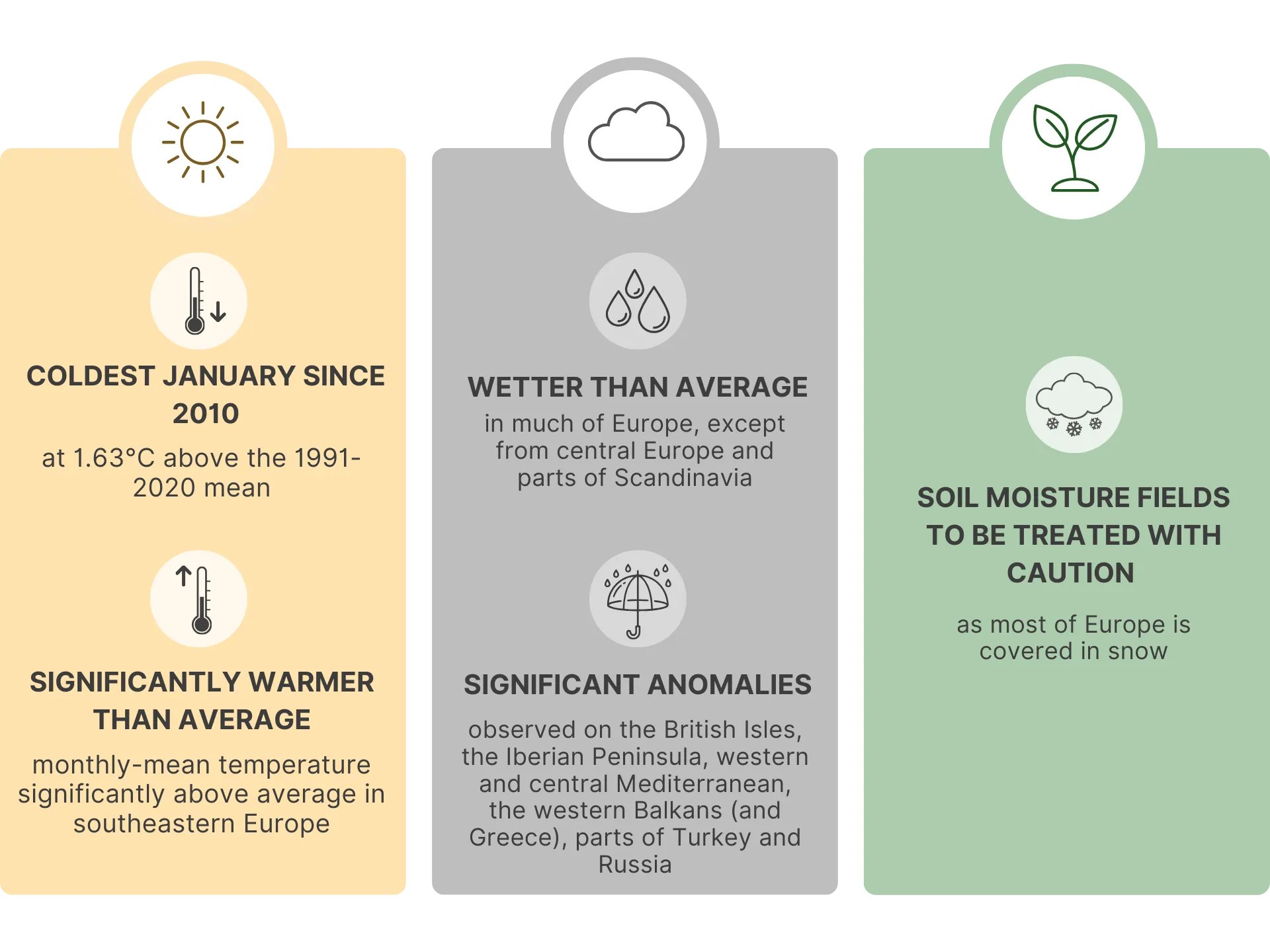
After months of warm-season forecasts that blurred into each other, the latest seasonal outlook from Augures Project reads differently. January 2026 broke the pattern. Europe recorded its coldest January since 2010, at 1.63°C above the 1991–2020 mean, with temperatures dropping well below normal across Germany, Poland, Scandinavia, and the northeast. Southeastern Europe stayed warm, but the rest of the continent got a proper winter month for the first time in a long while.
This analysis is based on seasonal climate data from the Augures project. The full climate outlook, including regional forecasts and interactive maps, is available in the Seasonal Climate Outlook for Europe – February 2026.
January was also wet. Record-high rainfall anomalies hit parts of the British Isles, the Iberian Peninsula, the western and central Mediterranean, the western Balkans and Greece, and sections of Turkey and Russia. Central Europe and parts of Scandinavia were drier than usual, but across most of the continent, soil profiles received a meaningful recharge. Much of Europe was still snow-covered on February 1st, so soil moisture numbers carry some uncertainty.
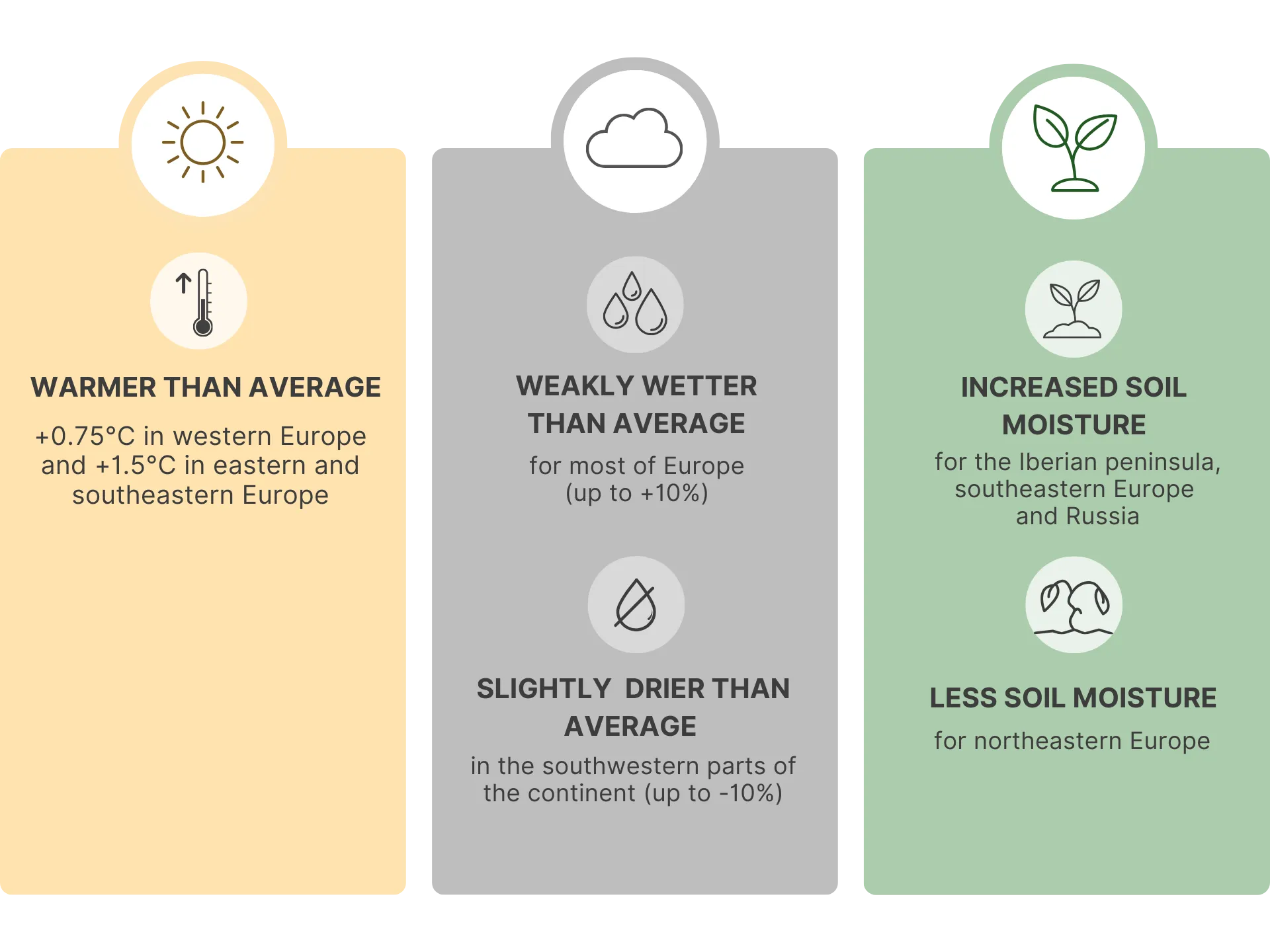
The spring forecast (March through May) projects temperatures +0.75°C above normal in western Europe, rising to +1.5°C in the east and southeast. Precipitation is expected to be weakly positive for most of the continent (up to +10%), with slightly drier patches in the southwest (up to -10%).
The biggest change from previous outlooks is in soil moisture. The Iberian Peninsula now shows positive soil moisture anomalies for the first time in months. So do southeastern Europe and Russia. The January rains did what months of marginal precipitation could not. Meanwhile, northeastern Europe has flipped to weakly negative soil moisture, after a cold, relatively dry January limited recharge there.
Why a cold January followed by a warm spring changes the agricultural equation
The cold January solved one of the problems that had been building since autumn. Winter cereals across central, northern, and eastern Europe needed chilling hours for vernalization, and December's warmth had left them running behind. January delivered. In most of these areas, the sustained cold should have pushed chilling accumulation back on track, which means more uniform flowering and better grain fill timing later.
State of the Climate – January 2026 Observations
The frost also did physical work on soils. In central and northern Europe, frost penetration broke up compacted surface layers, improving aggregate stability and aeration. For anyone who has spent recent springs wrestling with waterlogged, structureless topsoil after mild winters, this is a meaningful improvement heading into seedbed preparation.
The concern now is speed. A warm spring after a cold winter means a fast transition. Growing degree days pile up quickly when March and April run above normal, and that pulls crop development forward. Tillering, stem elongation, ear emergence: the intervals between these stages compress. If flowering lands during a dry spell, particularly where soil moisture is already marginal, there is less time and less water available for grain fill.
The wet January created its own set of follow-on effects. Heavy rain and snow suppressed some fungal inoculum over winter, washing or burying spores. But the residual moisture also sets the stage for early disease pressure once temperatures climb. Septoria tritici blotch and other foliar pathogens can rebuild quickly in mild, humid conditions. A clean canopy in February does not guarantee a clean canopy in April.
And where soils were saturated when the freeze hit, frost heave may have lifted shallow-rooted crops and disrupted surface drainage. The combination of frozen, waterlogged soils followed by a rapid thaw is worth inspecting before any spring fieldwork begins.
Seasonal Outlook – Forecasts for March-May 2026
Where the risks and opportunities land by region
Iberian Peninsula and western Mediterranean
The persistent drought signal that dominated every previous outlook has, at least temporarily, reversed. January's record rainfall recharged soil profiles across Spain, Portugal, and the western Mediterranean, and the forecast now shows positive soil moisture for Iberia. That has not happened in months.
The practical question is how olive groves, vineyards, and citrus orchards respond to sudden rehydration after prolonged stress. Root systems that spent months in dry soil will not instantly recover their full uptake capacity. Canopy growth, on the other hand, will respond quickly to the combination of moisture and warmth. With spring temperatures projected at +0.75°C above normal, budbreak and flowering will likely advance. That mismatch between what the canopy demands and what weakened roots can deliver is the main management challenge in these systems this spring.
There is also a storage question. The slightly negative precipitation signal for southwestern Europe (up to -10%) means the January recharge may need to carry crops further than it normally would. Topsoil moisture in March can look reassuring while deeper reserves are still insufficient for a full season. Early irrigation planning should factor that in.
Southeastern Europe and the Balkans
Southeastern Europe remains the wettest part of the outlook. Positive soil moisture anomalies from the January surplus sit on top of already adequate reserves, and the Balkans and Greece saw some of the highest rainfall anomalies on the continent.
The immediate problem is getting onto fields. Saturated soils and heavy equipment do not mix. Compaction caused by early entry on wet ground persists through the growing season and directly reduces yield potential. The warm spring (+1.5°C in the southeast) will speed up surface drying, but that can create a deceptive crust over still-wet subsoil. The window between "too wet" and "ready to plant" will likely be short, and the penalty for misjudging it is real.
For maize, sunflower, and sugar beet, planting decisions should follow soil moisture probes rather than calendar dates. Where winter wheat was established in autumn, scout for yellowing and poor tillering. Both are signs of root-zone oxygen deprivation from prolonged waterlogging, and they indicate where nitrogen losses through denitrification have likely already occurred.
Northeastern Europe
This region took the hardest hit from the January cold, with temperatures well below normal across Scandinavia, Poland, the Baltic states, and into Russia. The cold also came without much precipitation, which is why the outlook now shows weakly negative soil moisture here. That is a reversal from earlier forecasts, which had this region trending wet.
The cold did its job for vernalization: winter wheat and barley should have accumulated the chilling hours they need. The frost improved soil structure. Those are genuine benefits. The concern is what happens next. Snow cover will melt earlier under the projected warm spring, and the growing season will start ahead of schedule. Early crop growth will draw on soil moisture reserves that are already below average, and if spring rainfall arrives late or light, moisture stress could develop surprisingly early in the season.
Frost-thaw cycles during the transition weeks can also damage autumn-sown crops through frost heave, especially where snow cover was thin. Post-thaw inspections should happen before any inputs go on.
Central and western Europe
Germany, France, Benelux, and the UK got a mixed January: cold enough for useful frost penetration, with variable rainfall. The result is improved soil structure across much of the region, which should make spring fieldwork easier than in recent years.
The spring signal is mildly positive for precipitation (up to +10%) and moderately warm. Together with the frost-improved tilth, this points toward reasonable conditions for spring sowing. The adjustment to make is on timing. With temperatures above normal, crop development will outpace the calendar by one to three weeks. Nitrogen top-dressing, herbicide windows, and growth regulator applications all need to be pegged to crop stage, not to dates. Conservation tillage is worth maintaining to preserve the soil structure that frost delivered.
What to watch in specific cropping systems
Winter wheat, barley, and oilseed rape are in a stronger position than they were two months ago. Vernalization is largely back on track in central, northern, and eastern Europe. The risk now is that a fast spring compresses the reproductive window. If stem elongation and flowering are squeezed together under warm conditions, grain fill gets shorter. Nitrogen timing matters more than usual: applications should follow actual growth stage, which will run ahead of historical benchmarks.
Perennial crops (vineyards, olive groves, deciduous fruit) have gained from the cold January in terms of chill accumulation. Budbreak should be more uniform than it would have been after the warm December alone. But earlier, warmer conditions after dormancy breaks mean faster development, and faster development means more exposure to any late frost event. The question with frost is not just frequency; it is what stage the crop has reached when the frost hits. A frost at tight cluster is far more damaging than the same frost at dormant bud.
Spring-sown crops (maize, sunflower, sugar beet, potatoes, vegetables) face different establishment conditions depending on region. Wet soils in the southeast may delay planting and create uneven stands. Drier soils in the northeast could offer good tilth but demand attention to seeding depth and seed-to-soil contact. Central Europe is probably the best positioned, with frost-improved structure and adequate moisture.
What to do now
The January cold handed farmers some advantages that the previous warm months had been eroding. Vernalization is in better shape. Soil structure has improved where frost penetrated. Mediterranean drought has eased. None of those gains are permanent, and the projected warm spring means the window to act on them is compressed.
In wet regions (southeastern Europe, parts of Iberia, the western Balkans): protect soil structure above all. Wait for fields to drain below field capacity before entering. A few days of patience now avoids compaction that lasts all season. Inspect drainage systems before the thaw peak.
In drier regions (northeastern Europe, parts of Scandinavia): conserve moisture. Keep residue on the surface, minimise tillage, and control weeds early so they do not compete for limited water. If irrigation is available, plan for the possibility that demand arrives earlier than usual.
Everywhere: shift from calendar-based to stage-based management. Scout earlier. Apply inputs earlier. The warm spring will move crop development ahead by one to three weeks, and every operation tied to a fixed date rather than a growth stage risks being late.
Working with what we know and what we do not
The January cold was itself a reminder of forecast limits. It was not predicted by the previous seasonal outlook. Seasonal forecasts describe the most likely average conditions over months; they do not capture individual cold snaps or wet weeks. The clearest signal in this outlook is warmth. Plan around that. Then use field observations, soil probes, crop staging, and local rainfall data, to fine-tune decisions as the season unfolds.
The 2026 spring is starting from a stronger position than it looked like two months ago. The question is whether farmers can move fast enough to match the pace of a season that will not wait.
Note: This article provides guidance based on the latest seasonal outlook data available. Farmers should monitor local weather conditions and consult with regional agricultural extension services for location-specific recommendations.


