
Italy's Civil Protection Department (Dipartimento della Protezione Civile, DPC), which issued a weather warning in agreement with the regions concerned, assessed an orange alert for meteorological and hydrogeological risk in Puglia and Basilicata for Monday 2 November 2026, with heavy rain, thunderstorms, strong gusts and local hail, while the meteorological service of the Italian Air Force (MeteoAM) has issued a red rain warning, the top level on the European Meteoalarm scale, for the same regions and for Campania. The forecast rain comes to an area where, according to the 26 October bulletin of the European Commission's Joint Research Centre (JRC), low soil moisture was constraining seedbed preparation for winter crops in central and southern Italy, and where the grid point in central Puglia received 63% of its normal rain in the 90 days to 30 October, according to a Wikifarmer analysis of NASA data.
MeteoAM issued its highest rain warning level for three regions
The red rain warning, which MeteoAM had issued on 1 November for the whole of 2 November from 01:00 Italy time, remains in force in the update issued at 11:25 Italy time (10:25 UTC) on 2 November for Puglia, Basilicata and Campania until 00:59 on 3 November, that is until 23:59 UTC on 2 November. For the same period Puglia also has orange warnings for thunderstorms and wind and Basilicata an orange warning for thunderstorms. For the early hours of 3 November, from 01:00 to 06:59, MeteoAM gives Puglia a yellow warning for rain and an orange one for thunderstorms, with a yellow wind warning that runs until 18:59. On Meteoalarm itself, MeteoAM states that its warnings for Italy describe only the intensity and recurrence of the phenomena, do not assess impacts on the ground and are not the official alert messages of the national civil protection service. The official alerts are those of the civil protection system, which for 2 November has Puglia and Basilicata on orange.
The orange alert covers meteorological and hydrogeological risk
In its press release of 1 November, the DPC says a low-pressure area moving down from the Balkans towards the Tyrrhenian Sea is bringing instability to central and southern Italy, and that its weather warning forecasts scattered to widespread rain from the early hours of 2 November, including showers and thunderstorms, over Abruzzo, Molise and Sicily, spreading to Campania, Calabria, Puglia and Basilicata, persistent over Basilicata and along the eastern Apennine slopes of Abruzzo and Molise. The rain will come with intense showers, strong gusts, local hail and frequent lightning. Strong to gale-force northerly winds are forecast to blow from the morning over Lazio, Campania and Sicily and then spread to Basilicata and Puglia, where they will turn easterly. The DPC says the weather could cause hydrogeological and hydraulic problems, and on that basis it assessed an orange alert for Puglia and Basilicata and a yellow one for Calabria, Campania, Molise, Abruzzo and Sicily. The regional civil protection services handle the details for each area and the preventive measures.
ECMWF forecasts more rain near Foggia than in central Puglia
In the forecast of the European Centre for Medium-Range Weather Forecasts (ECMWF) run at 00:00 UTC on 2 November, the grid point near Foggia, at 41.50°N 15.50°E, gets 52.2 mm on 2 November and 60.8 mm over the three days from 2 to 4 November. Over the same three days, the point near Rutigliano, south-east of Bari, gets 41.5 mm, the point in the Murge in central Puglia 41.3 mm and the point on the Puglia-Basilicata border near Ginosa, north of the Metapontino, 38.3 mm, with most of the rain falling on 2 November at every point. Each grid point stands for an area of roughly 28 by 21 km, so the forecast does not show the local peaks of the thunderstorms the DPC describes.
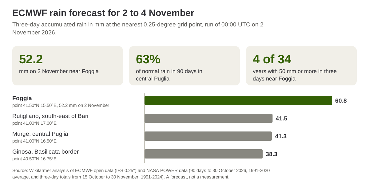
Source: Wikifarmer analysis of ECMWF open data (IFS 0.25°), run of 00:00 UTC on 2 November 2026, and of NASA POWER data for 1991 to 2024. A forecast, not a measurement.
The warning comes after three months with less rain than average
In data from NASA's POWER project, the grid point in central Puglia, at 41.0°N 16.5°E, received 85.0 mm in the 90 days to 30 October, against a 1991 to 2020 average of 135.3 mm for the same days, or 63%, while the point near Rutigliano received 65% and the point near Foggia 72%. In the last 30 days of that period, rain was close to normal in central Puglia, at 59.4 mm against 59.2, and above normal near Foggia, at 69.4 mm against 51.5. In its JRC MARS bulletin of 26 October, the JRC says that in central and southern Italy low soil moisture is constraining seedbed preparation and the start of winter crop sowing, although the relatively long sowing window still leaves enough time for field work. The same bulletin says winter barley sowing has been delayed in the central and southern regions by persistent drought, and that for Italy as a whole seedbed preparation for durum wheat had not yet started, in a season in which winter sowing in Europe started with dry soils in the centre and waterlogged ones in the Baltic states.
Near Foggia three-day totals of 50 mm or more occurred in 4 of 34 years
Between 15 October and 30 November, the largest three-day rain total at the point near Foggia reached 50 mm or more in 4 of the 34 years from 1991 to 2024 in the NASA POWER data, in 1997, 2004, 2015 and 2018, and only in 2 of them, 2004 and 2015, within November. At the central Puglia point the same happened in 3 of the 34 years and at the point near Rutigliano in 7, according to a Wikifarmer analysis. ECMWF's forecast of 60.8 mm for the Foggia point is above that threshold, while the other three points stay below it. The NASA data have a resolution of about half a degree and ECMWF's 0.25 degrees, so the comparison only gives the order of magnitude.
Station readings will show how much rain reached the fields
For cereal growers preparing to sow, the forecast rain bears on the soil moisture the JRC describes, while the intense showers, hail and strong gusts the DPC mentions also concern crops already in the field. The information of immediate use is therefore the alerts of the regional civil protection services, together with general guidance on the timing of winter wheat sowing. The picture will be completed by station readings for 2 and 3 November, which will show whether the rain reached the levels in the warning, and with the next JRC MARS bulletin for Europe, scheduled for 23 November.
Frequently asked questions
What is the difference between MeteoAM's red warning and the Civil Protection orange alert?
MeteoAM's red warning on Meteoalarm describes, in the service's own words, only the intensity and recurrence of the weather and contains no assessment of impacts. The orange alert assessed by the DPC belongs to the official civil protection system and concerns the hydrogeological and hydraulic problems the weather could cause.
Which days do the warnings cover?
The DPC orange alert covers Monday 2 November. MeteoAM's red rain warning was issued on 1 November for the whole of 2 November, from 01:00 to 00:59 on 3 November Italy time, and the 11:25 update of 2 November kept it in force until 00:59. For the early hours of 3 November, Puglia has a yellow rain warning and an orange thunderstorm warning.
How much rain is forecast for Puglia?
ECMWF's 2 November forecast gives 60.8 mm for 2 to 4 November at the grid point near Foggia, of which 52.2 mm on 2 November, and 38.3 to 41.5 mm at two points in central Puglia and one on the Basilicata border. Thunderstorms can bring locally more rain than the average for a grid point.
How often does this much rain fall in October and November?
In NASA POWER data for the point near Foggia, three-day totals of 50 mm or more between 15 October and 30 November occurred in 4 of the 34 years from 1991 to 2024, in central Puglia in 3 and near Rutigliano in 7.
How dry were the soils before the rain?
In the 90 days to 30 October, the central Puglia point received 63% of its normal rain, while the last month of that period was close to normal. On 26 October the JRC reported that low soil moisture is constraining seedbed preparation for winter crops in central and southern Italy.
Important notes
The MeteoAM warnings come from the Meteoalarm feed for Italy as retrieved at 11:45 UTC on 2 November 2026, and the DPC alert from its press release of 1 November. The article was written while the warnings were in force and before any station readings were published, so it contains no recorded rain or damage. The rain forecasts are ECMWF's, run of 00:00 UTC on 2 November, and the totals were computed from the model's accumulated rain at the nearest grid point, with each point named by its area or nearest town. Wikifarmer computed past rain and the frequency of three-day totals of 50 mm or more from NASA POWER daily data, with 1991 to 2020 averages for the same days. The frequency was counted over 1991 to 2024 because the October 2025 values at the Puglia points are several times the normal and have not been checked against stations. These data describe grid cells, not stations, and the latest available day was 30 October. The description of sowing comes from the JRC MARS bulletin of 26 October 2026.
Sources
- Dipartimento della Protezione Civile. (2026, 1 November). Maltempo: allerta arancione in Puglia e Basilicata.
- Meteoalarm, EUMETNET. Warnings for Italy, Puglia, warnings of the Servizio Meteorologico dell'Aeronautica Militare, accessed 2 November 2026.
- Joint Research Centre, European Commission. (2026, 26 October). JRC MARS Bulletin, Crop monitoring in Europe, Vol. 34 No. 9.
- European Centre for Medium-Range Weather Forecasts. Open data, IFS 0.25°, run of 2 November 2026, 00:00 UTC.
- NASA Langley Research Center. POWER, Prediction of Worldwide Energy Resources, daily data, accessed 23 October and 2 November 2026.