

The weather station at Curicó, in Chile's Maule region, recorded 90.8 mm of rain between 21 September and 20 October 2026, the third-highest total for that period since 1991, after 1997 and 2015, both years of a very strong El Niño, according to a Wikifarmer analysis of daily data from the Chilean Meteorological Directorate (Dirección Meteorológica de Chile, DMC). The rain fell after September, the month in which Chile's Agricultural Research Institute (Instituto de Investigaciones Agropecuarias, INIA) expected cherry trees in the O'Higgins region to move from winter dormancy into the start of flowering. In the official sources Wikifarmer examined, there is no estimate of the crop yet.
Curicó received 55 mm of rain in two days in October
Most of the rain at Curicó fell on 5 and 6 October, with 21.8 mm and 33.2 mm respectively, which makes 55.0 mm in two days. The 1991 to 2020 average for the whole 30 days from 21 September to 20 October is 27.5 mm, so this year's total is about 3.3 times the average. Two other DMC stations in cherry areas also recorded high totals over the same period, Rancagua in the O'Higgins region with 85.0 mm and Panguilemo, near Talca, with 70.6 mm. For Rancagua the DMC has no complete record of this period in any year before 2016, and the Panguilemo history was not examined, so the comparison with earlier years covers Curicó only.
INIA places the start of cherry flowering in O'Higgins in September
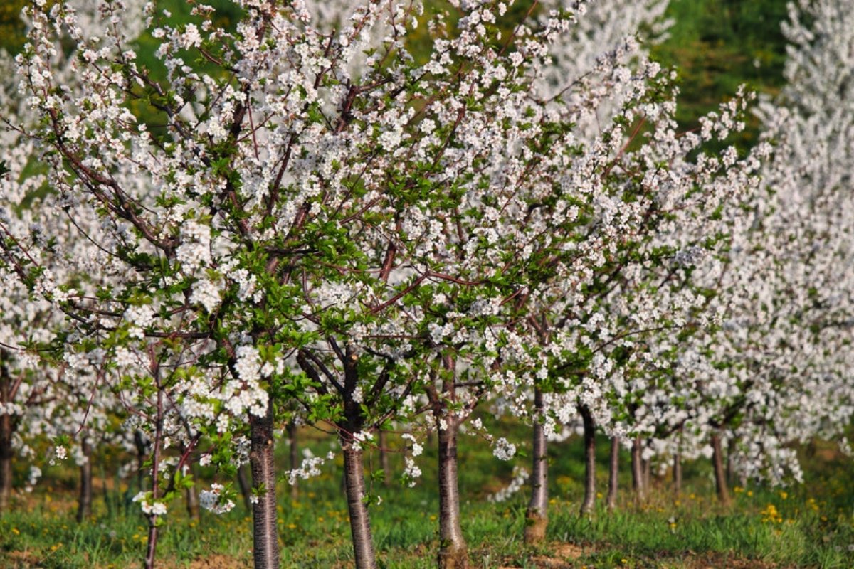
In its September 2026 bulletin for the O'Higgins region, published by INIA with Chile's Ministry of Agriculture, stone fruit trees, cherries included, pass during September from the end of winter dormancy to the start of flowering and the first bud break. Seasonal forecasts, the bulletin adds, point to a southern-hemisphere spring with above-normal rain and moderate temperatures, conditions that favour pathogens. With high accumulated moisture and gradually rising solar radiation, the bulletin recommends strict disease control against Botrytis in cherries and against Monilia and Monilinia, the fungi behind brown rot in cherries, and frost-protection systems kept ready for any late frost that could damage flowering and pollination in cherry trees and early fruit set. In the matching bulletin for Maule, where Curicó lies, INIA refers to the start of growth in vineyards and cherry orchards and recommends preventive protection against fungal diseases.
Only 1997 and 2015 had more rain over the same period
In the 35 years from 1991 to 2025, rainfall at Curicó between 21 September and 20 October exceeded this year's 90.8 mm only twice, in 1997 with 133.5 mm and in 2015 with 102.1 mm. At least twice the average, that is 55 mm or more, fell in 4 of the 35 years, in 1997, 2006 with 63.4 mm, 2012 with 69.7 mm and 2015, while in 21 of the 35 years the same 30 days brought less than 20 mm.
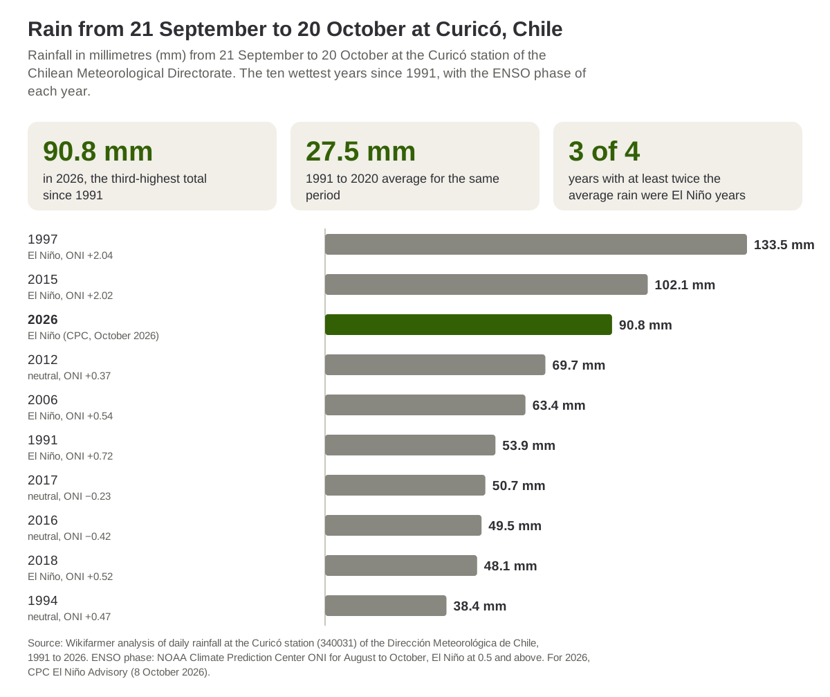
Source: Wikifarmer analysis of daily rainfall at the Curicó station (340031) of the Dirección Meteorológica de Chile, 1991 to 2026. ENSO phase: NOAA Climate Prediction Center ONI for August to October. For 2026, CPC El Niño Advisory (8 October 2026).
In El Niño years the median rainfall at Curicó reached 48.1 mm
When the years are grouped by the ONI index of the US Climate Prediction Center (NOAA Climate Prediction Center, CPC) for August to October, the 9 years with the El Niño phenomenon between 1991 and 2025 had a median rainfall at Curicó of 48.1 mm over the same 30 days, against 13.4 mm in the 17 neutral years and 7.7 mm in the 9 La Niña years. Of the 4 years with at least twice the average rain, 3 were El Niño years, 1997, 2006 and 2015, and the fourth, 2012, was neutral. The two wettest, 1997 and 2015, also had the two highest index values in the series, +2.04 and +2.02.
This is an association and does not work as a rule, since in 2023, a strong El Niño year with an index of +1.50, Curicó received only 3.8 mm over the same period. For 2026, the CPC's diagnostic discussion of 8 October keeps the El Niño Advisory in place, reports that the sea surface temperature anomaly in the east-central equatorial Pacific, the region the ONI tracks, reached 2.1 degrees Celsius above normal over the past month, and states that a strong to very strong El Niño is likely to continue through January to March 2027, with a chance above 83%.
No official estimate of the crop or of exports exists yet
In the official sources Wikifarmer examined up to 27 October, including the cherry publications of Chile's Office of Agricultural Studies and Policies (ODEPA), there is no estimate of the volume of the 2026/27 cherry crop or of cherry exports. In remarks published by the newspaper El Rancagüino on 23 October, the regional Agriculture secretary for O'Higgins, Carlos Valdés, said that as much information as possible is being gathered to quantify what is happening. According to the newspaper, the assessment involves the agricultural risk management committee (CARGIR), INIA with data from 50 weather stations in the region, the Agricultural and Livestock Service (SAG) with fruit export data for 2020 to 2025, INDAP and the General Water Directorate (DGA). No figures and no date for results were given. In the same report the newspaper describes hail on 8 October on 24 hectares of cherries on a farm in Rengo, information that comes from the report and not from an official assessment, while the regional secretary noted that hail falls unevenly from one field to the next.
The ECMWF forecast gives 13.2 mm of rain up to 5 November
In the forecast of the European Centre for Medium-Range Weather Forecasts (ECMWF) issued at 00:00 UTC on 27 October, the grid point at 34.5° S 71.0° W, in O'Higgins, accumulates 13.2 mm of rain over ten days, up to 5 November, with a maximum 3-day total of 6.1 mm. This is ECMWF's forecast, it changes from one run to the next, and it refers to a single grid point at 0.25 degree resolution.
For growers in central Chile and for importers in Asia, Europe and North America who buy Chilean cherries, the first official picture of the damage will come from the assessment of the O'Higgins regional Agriculture office, for which no date has been announced, while INIA publishes agroclimatic risk bulletins by region every month. Rain in one area is one of several supply factors, since cherry prices in international markets are set each year by supply from many producing regions.
Frequently asked questions
How much rain fell in Chile's cherry areas in October 2026?
The Curicó station of the Chilean Meteorological Directorate recorded 90.8 mm between 21 September and 20 October 2026, Rancagua 85.0 mm and Panguilemo, near Talca, 70.6 mm. The 1991 to 2020 average at Curicó for the same period is 27.5 mm.
How often does this much rain fall at Curicó at this time of year?
From 1991 to 2025, more rain over the same 30 days fell only in 1997 and 2015, and at least twice the average in 4 of the 35 years.
Does El Niño always bring more rain to central Chile at this time of year?
Not always. In the 9 El Niño years since 1991 the median rainfall at Curicó was 48.1 mm, well above neutral and La Niña years, but in 2023, a strong El Niño year, only 3.8 mm fell.
Is there an official estimate of damage to Chile's cherries?
Up to 27 October there was none in the official sources examined. According to El Rancagüino, the O'Higgins regional Agriculture office is gathering data together with INIA, SAG, INDAP and the DGA, with no date given for results.
Will it rain in central Chile in the next ten days?
ECMWF's forecast of 27 October gives 13.2 mm of rain over ten days, up to 5 November, at the grid point in O'Higgins.
Important notes
Wikifarmer analysed daily rainfall at the DMC station Curicó (340031), as published on the service's annual pages, for 1991 to 2026, with no missing days in the period examined. The 30 days from 21 September to 20 October were chosen to cover the weeks after September, the month in which INIA places the start of cherry flowering in O'Higgins, and the 27.5 mm average was calculated by Wikifarmer from the 1991 to 2020 daily data, so it is not the DMC's official climate normal. Each year's ENSO phase was set in a simplified way from the CPC's ONI value for August to October, with El Niño at 0.5 and above and La Niña at −0.5 and below, while the CPC's official definition requires five consecutive overlapping seasons. The 2026 index value has not yet been published. A single station does not describe the whole area of cherry orchards, and the data show an association, not causation. The forecast is ECMWF's, the ten-day total was calculated from the model's accumulated rainfall, and the hail report comes from local press coverage. The article does not estimate damage or export volumes and gives no spraying advice.
Sources
- Dirección Meteorológica de Chile. (2026). Informe anual de agua caída, estación Curicó (340031), annual pages for 1991 to 2026, retrieved 23 and 27 October 2026 (in Spanish).
- Dirección Meteorológica de Chile. (2026). Monthly rainfall pages for September and October at Rancagua (340045), September and October, and Panguilemo, Talca (350028), September and October, retrieved 23 October 2026 (in Spanish).
- INIA and Ministerio de Agricultura de Chile. (2026, September). Boletín Nacional de Análisis de Riesgos Agroclimáticos para las principales especies frutales y cultivos, y la ganadería, regions O'Higgins and Maule (in Spanish).
- NOAA Climate Prediction Center. (2026, 8 October). ENSO Diagnostic Discussion.
- NOAA Climate Prediction Center. Oceanic Niño Index (ONI), retrieved 27 October 2026.
- European Centre for Medium-Range Weather Forecasts. Open data, IFS 0.25°, run of 27 October 2026, 00:00 UTC.
- El Rancagüino. (2026, 23 October). Granizadas y lluvias dañan cultivos en O'Higgins: Agricultura prepara catastro de pérdidas (in Spanish).