

Technologies of precision farming
Main satellite constellations, correction systems, and georeferencing
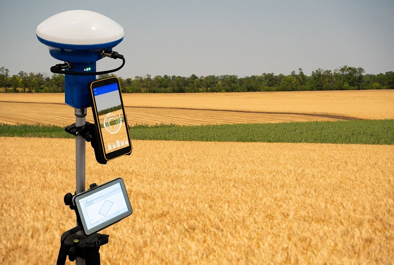
The basis of precision agriculture systems in the field is the GNSS (Global Navigation Satellite System), consisting of a network of geostationary satellites in communication with each other. Major nations have a network developed by them, for example, the GPS of the United States (31 satellites), Galileo of the European Union (24 satellites), GLONASS of the Russian Federation (24 satellites), and BeiDou of China (35 satellites). The position determination provided by GNSS alone is limited to the number of satellites available at any given time and is subject to the accumulation of an error of ±30 cm.
They are assisted by a series of minor constellations functional for signal correction called DGPS (Differential Global Positioning System). The European Union has the EGNOS network of geostationary satellites in orbit that offers a completely free correction service that reduces the error to ±10 cm.
For operations that require an accuracy of a centimeter (±2 cm), such as planting and transplanting, other correction systems can be used, such as RTK (Real Time Kinematic). In practice, the signal is sent to the moving machine (rover) via radio waves or UMTS (mobile cellular network) signal from a series of transmitters on the ground or from a radio antenna installed on the farm. The accuracy of RTK allows guidance lines to be stored and reused for subsequent operations with extreme accuracy and consequent savings in time and fuel.
GPS guidance systems
Assisted steering solutions certainly stand out among the major innovations introduced in agriculture. Numerous companies produce these systems, but they all use the same principle: a receiver antenna placed on the farm machine connected to the steering system, accompanied by angle sensors mounted on the wheels, and a special terminal installed in the cab.
Satellite guidance systems are divided into:
- Assisted guidance:the simplest and most economical guidance system. It is based on manual guidance assisted by an on-board display that provides the operator with a graphical display of his position and the trajectory to be followed by observing the light indicators on the display's LED bar;
- Semi-automatic (or parallel) driving: Thissystem is more technologically advanced and expensive than the previous one and can be governed by an electric steering wheel or directly by a solenoid valve inserted in the hydraulic system and is controlled by the on-board computer guided by the RTK signal;
- Autonomous driving: Itrequires no human intervention whatsoever. The tractor is guided by GPS and a series of sensors that can detect obstacles of various kinds and can manage headland turns and equipment completely autonomously;
The improved performance of GPS guidance systems and the repeatability over time of operations along the same guidance line have led to Controlled Traffic Farming (CTF), which involves confining the passage of machinery in traffic lanes or streetcar lines (tracks).
The benefits are many: reduced trampling, maintenance of soil structure, fuel, and time savings; unfortunately, these are not yet justified against the requirements to apply CTF. In fact, farmers and operators are required to have an in-depth technical knowledge of satellite guidance systems, purchase RTK guidance systems, and adaptation of machinery and equipment to traffic lanes are necessary, and it is hardly possible to adapt the track of harvesting machines.
As this is a relatively recent practice that needs further technical and operational refinements, it is not yet widely used. However, a variation of the CTF based on the concept of wide-track (10 m or more) tool-carrying vehicles is becoming popular, an example being the NEXAT (find an in-depth discussion at: https://www.nexat.de/en/).
ISOBUS standard
Over the years, major agricultural equipment manufacturers began to develop increasingly technological and complex equipment that required a large number of control units and pushbuttons to operate them, causing an increase in the complexity of operations and stress while working.
In 2008, in order to simplify operations and improve operator welfare by enabling the management of implements from a single terminal, a group formed by major equipment manufacturers founded the AEF (Agricultural Industry Electronic Foundation) following the guidelines of the pre-existing SAE-J1939 standard typical of the automotive industry, introducing ISO-11783 and adapting the standards to the needs of the agricultural sector. The founding idea of the ISOBUS project is encapsulated in the concept of "plug & play," or the connection and interoperability between machinery with the simple use of a dedicated socket.
The operating scheme of the ISOBUS system is straightforward and can be schematized in the following way: on board an implement, there is an ECU, the implement ECU, which through the ISOBUS port on the tractor communicates in conjunction with the tractor's computer (T-ECU), with the Universal Terminal (UT) integrated into the tractor's on-board display, from which the implement can be controlled directly or with the help of dedicated devices.
The main features offered by the ISOBUS system are:
- UT (Universal Terminal): management of implementing functionality on any ISOBUS terminal
- AUX-N (Auxiliary Control): allows the management of additional terminals such as joysticks and pushbuttons, useful for simplifying ISOBUS implement management operations;
- TECU (Tractor Electronic Computer Unit): serves as a platform for all other ISOBUS functions by making tractor operating data available;
- ISB (ISOBUS Shortcut Button): allows the deactivation of implementing functions activated via ISOBUS terminal;
- TIM (Tractor Implement Management): a multi-product, multi-producer ISOBUS solution that allows the implement to control certain tractor functions such as direction, forward speed, engine rpm, and tractor hydraulics;
- FS (File Server): serves as a central hub for data storage or retrieval and allows data exchange with ISOBUS and external devices (USB or cloud);
- TC-BAS (Task Controller-Basic): records and exchanges the values of the task performed provided by the ISOBUS implement;
- TC-GEO (Task Controller GEO-Based): management or scheduling of operations based on GPS position, for example, in the case of variable rate applications;
- TC-SC (Task Controller Section Control): automatic section management depending on GPS position and desired degree of overlap, useful for section control of sprayers and seeders;
More information regarding AEF is available at the following link: https://www.aef-online.org/it/home.html
Proximal and remote sensing
A key feature of precision agriculture is definitely the continuous and timely monitoring of environmental and crop conditions, made possible by the multitude of sensors available on the market.
Depending on the specifications of the sensors and the method of detecting environmental and crop parameters, two types of monitoring can be distinguished:
- Proximal sensing or proximity monitoring: in which data is collected by sensors placed in close proximity to the crop. Common sensors in the field include weather stations, fixed cameras and video cameras, soil moisture and temperature sensors, leaf wetness sensors, and insect traps. In addition, different types of sensors can be installed on board tractors: infrared sensors capable of detecting the degree of the vigor of the crop and performing the most appropriate fertilization for its needs, electrical conductivity sensors for characterizing soils and their organic matter and nutrient content, or soil compaction sensors for working at variable depths.
The advantages of proximal sensing lie in the cost-effectiveness of the sensors and the continuous collection of data directed to platforms dedicated to their interpretation and use (FMIS). By contrast, in the case of sensors installed in the field, it only returns an estimate of the general condition of the plots;
- Remote sensing or remote monitoring: made possible by drones, helicopters, airplanes, or satellites equipped with special cameras (RGB, multispectral, etc.) capable of capturing images within the visible spectrum and not visible to the human eye. Remote sensing makes it possible to operate in large and difficult-to-access areas in short periods and with high resolution and accuracy of the data. Unfortunately, using assets such as airplanes and helicopters requires specialized personnel and sophisticated, expensive technologies. It has high operational costs, so they are used for research or military purposes. In contrast, satellites provide quality imagery and are often available free of charge, as in the case of the European Copernicus environmental monitoring satellite network, which has several satellites in orbit, including two dedicated to agriculture, the Sentinel-2 (available at: https://apps.sentinel-hub.com/eo-browser/). The disadvantages of satellite sensing are operational in that it provides images every 3-5 days and is climatic in nature due to interference such as clouds and precipitation.
Aerial surveying carried out with chambers of various types provides useful indices for assessing crop and soil conditions. Here are some of the most common ones, distinguished by category:
- Vigor
- NDVI (Normalized Difference Vegetation Index) describes the vigor status of the crop;
- SAVI (Soil Adjusted Vegetation Index) is the version of NDVI to which a correction factor is applied to exclude disturbances caused by soil reflectance;
- LAI (Lead Area Index) measures the area occupied by vegetation in relation to the area covered;
- Chlorophyll
- TCARI (Transformed Chlorophyll Absorption Reflectance Index), which measures chlorophyll content in tissues;
- OSAVI (Optimized Soil Adjusted Vegetation Index), which aggregated with TCARI, corrects for the error caused by soil reflectance;
- NDRE (Normalized Difference Red Edge Index) also measures chlorophyll content and is useful for estimating nitrogen requirements or stress caused by its deficiency;
- Water stress
- NDMI (Normalized Difference Moisture Index) indicates the water content in crop tissues and highlights potential stresses;
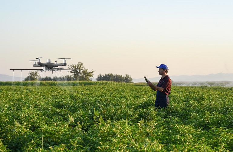
Drones or UAV (Unmanned Aeriel Systems)
For precise crop monitoring, drones represent the right trade-off between purchase and operating costs, data collected, and information that can be extrapolated, and they are one of the most relevant and promising innovations in agriculture and have already found varied uses, from monitoring to crop defense for some years.
First, it is good to clarify the meaning of Unmanned Aircraft Systems. The term UAS is often referred to as SAPR (Remotely Piloted Aerial System) by major air traffic control agencies. As the word system (system) suggests, it does not refer exclusively to the drone itself but to the complex consisting of the drone, the control station (operator), and the link between the two (radio control). By regulation, the operator must be able to maintain visual contact with the drone at all times.
Drones have varying characteristics depending on the type of flight organs (fixed wing or propeller), presence, and type of cameras and instruments that can be installed. Commercially available are drones equipped with micro granulators for distributing granules, pellets, or even pollen for assisted pollination, tanks combined with nozzles for distributing liquid products such as plant protection products or liquid fertilizers, or dispensers for the release of beneficial or antagonistic insects.
If you are interested in approaching the world of UAS, we recommend that you take the free OPEN A1-A3 Category Certificate valid for the European Union at the following link: https://learningzone.eurocontrol.int
FMIS and integrated DSS
The volume of data generated by sensors and machinery requires dedicated information technology tools: farm management information systems (FMIS). They are information systems used to assist farmers in recording activities.
Typical functions of FMISs are: the ability to locate one's farm define plots and boundaries, set crop cycle and rotations, record operations (tillage, planting, nutrition, irrigation, defense, and harvesting), monitor the machinery fleet through telemetry, operating parameters and consumption, to scheduled maintenance and fault detection through alerts. And again, manage the economic and administrative side of the business, collect data from sensors, and receive useful advice to guide choices provided by integrated Decision Support Systems (DSS).
DSS is a valuable ally in planning and executing crop operations in the best possible way. They are governed by specific algorithms that can process large amounts of data and return specific advice depending on the farmer's needs: the period of disease development, products and time most suitable for intervention, the optimal time for planting different crops, timing and volumes of water needed to meet the crop's water requirements, etc.
In addition, in FMIS platforms, it is possible to import, view and process all the maps generated by machinery or satellites in order to create special prescription maps, georeferenced maps in which specific areas of a field can be designated and assigned specific applications values for targeted distribution of seed, fertilizer, crop protection agents or other types of products. Once a prescription map is created, it can be sent via cloud or USB devices directly to the tractor connected to equipment capable of variable rate distribution.
The emergence of a vision focused on timeliness, the precision of intervention, and the use of forecasting tools, not linked simply to imported or machinery-generated data but to overall farm management, combined with the aid of increasingly high-performance data interpretation tools, has marked the transition from precision agriculture to the era of smart farming and digital farming based on the intelligent use of data and the creation of value from it.
An outlook for the future
What does the future hold? The ways forward are numerous and being explored. We can only try to compile a list of the best-known and explored ones so far that promise to revolutionize how agriculture is conceived again.
Speaking of the near future, automation is at the forefront. The market offers autonomous robots capable of planting or transplanting seeds, performing mechanical, chemical, or laser weeding using optical sensors and weed recognition algorithms, autonomous tractors capable of performing tillage, ground-based drones capable of detecting crop health status or the presence of pests, and autonomous harvesting robots.
Closely related to automation is the use of artificial intelligence, which is already used on some machinery to detect pests or diseases and will, in the future, be an integral part of DSS and provide technical advice to farmers.
Consumers, increasingly attentive to the provenance and quality of food, are clamoring to know the processes associated with the products they buy. Blockchain will play a key role in ensuring the authenticity of the supply chain, allowing the entire product lifecycle to be tracked from the field to the table in a transparent and, above all, unalterable way.
In general, smart farming and precision farming technologies will help track production processes and demonstrate their sustainability through dedicated practices such as carbon farming or special indices that can estimate or calculate carbon footprint, water footprint, and greenhouse gas (GHG) emissions.

