

Introduction
Earth observation uses sensors to collect information about the Earth's surface from a distance. The COALA project applies Earth Observation technologies to create precision agriculture methodologies to optimise crop yields and manage nutrient input, such as by limiting the use of fertilisers. But the applications of earth observation go beyond farming. Earth observation has proven to be an effective tool in water management, precision irrigation, dryland crop management, and detecting non-compliance with regulations related to water use. In our first article for Wikifarmer, we introduced the COALA project and discussed the application of precision agriculture and its benefits for farmers. This article will build upon these concepts and explore specific case studies where earth observation can be applied beyond nutrients and crop yield.
Case study 1: Water management
ANBI Campania is a non-profit organisation based in Italy and plays a critical role in the COALA project, a collaborative effort to develop advanced logistics analytics solutions for cloud-based supply chains. The organisation's expertise in monitoring water resources and allocation and its mission to promote sustainable irrigation management make it a valuable partner in the project. ANBI Campania covers over 60% of the region and aims to adopt innovative irrigation management methods to help save water.
ANBI Campania's irrigation management system is based on annual declarations of farmers. In the past the consortium produced and validated maps of irrigated areas, crop type classification, crop evapotranspiration, and net and gross irrigation water requirements. Their projects have resulted in increased compliant declarations and the ability to identify non-compliant assertions quickly. In addition, the products and services derived from the Copernicus satellites helped the consortium interact and communicate with farmers better, promoting fair and responsible water usage while reducing water waste.
In summary, ANBI Campania's extensive experience in water management and its partnership with the COALA project highlights the importance of experienced water managers in developing advanced analytics solutions for sustainable water use. The consortium's success in adopting innovative irrigation management methods and implementing the 'Regional Irrigation Advisory Plan’ is an excellent example of the positive impact of advanced technology in water management. The DIANA project demonstrated the importance of implementing a monitoring system to ensure that water is allocated equitably and to promote responsible water use. ANBI Campania's contributions to these projects showcase the importance of collaboration and innovation in providing sustainable water use for the benefit of all stakeholders.
 Case study 2: Precision irrigation
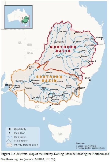
One case study of the COALA project's application is managing irrigation in the Murray Darling Basin in Australia. The Murray Darling Basin is a large agricultural region that relies heavily on irrigation for crop production. The COALA project partnered with the Australian company Rubicon Water to develop an advanced water management system that uses cloud-based logistics analytics to improve irrigation efficiency and reduce water usage.
The project involved the installation of sensors and monitoring devices at various points in the irrigation network, including water meters, flow sensors, and weather stations. These devices provide real-time data on water usage, weather patterns, and other factors impacting irrigation efficiency. The data is then analysed using the COALA project's logistics analytics solutions, which can identify opportunities for optimisation, predict future demand, and improve resource allocation. As a result, the project has helped to improve irrigation efficiency by over 20%, resulting in significant cost savings for farmers and reducing the environmental impact of water usage in the region.
The COALA project's irrigation management system in the Murray Darling Basin is a valuable case study in applying advanced logistics analytics solutions in the agricultural sector. By providing real-time insights into irrigation activities and predicting future demand, the project has helped to improve efficiency, reduce water usage, and improve the sustainability of agriculture in the region. The project has also demonstrated the potential for cloud-based logistics analytics solutions to be applied to other agricultural areas worldwide, helping to address the global challenge of feeding a growing population while preserving natural resources.
 Case study 3: Dryland crop management
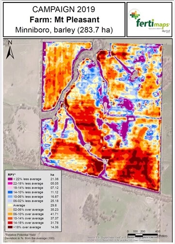
The COALA project is a joint effort between AgriSat and UCLM to generate satellite-derived products to assist in managing dryland crops in the Mallee and Wimmera regions of Victoria, Australia. As part of the 2020 campaign, four COALA products were generated to help farmers manage dryland crops. These products include day-to-day crop monitoring, management zone maps, nitrogen nutrition index (NNI), and crop yield estimation using the MYRS model.
To evaluate the effectiveness of the COALA products, two growers collaborating on the project, Tim McClelland and Cameron Taylor, were interviewed about their on-farm experience. One of the most significant advantages of the COALA products was using time series of satellite images to monitor the crop week by week. This allowed the growers to detect weedy areas within the plot at the crop's early stages and adapt their management accordingly.
Another helpful tool provided by the COALA products was the generation of management zone maps (MZM), which differentiate the different zones of the productive potential of the plot. The MZMs help detects different productive zones of a plot year by year, providing a quick and accurate analysis of the plot's history. This information allows farmers to determine if a management problem caused differences in a specific year or if patterns are repeated year after year. The MZMs are critical for different management tasks, such as taking samples in the distinct zones of the plot or for variable rate fertilisation, harvesting (production and quality), or sowing.
The COALA products also provided early detection of possible nitrogen deficiencies in crops, which is essential for optimal crop growth. Additionally, the crop yield estimation using the MYRS model allowed for daily monitoring of the crop's NDVI evolution, meteorological data, and crop water stress estimation. This information helped farmers predict crop yield and optimise their management practices accordingly.
Overall, the COALA project provided significant benefits to the participating farmers, including early detection of potential issues and the ability to adapt management practices accordingly. In addition, the use of satellite-derived COALA products helped the growers optimise their crop yields and make informed decisions about management practices.
Case study 4: Non-compliance detection
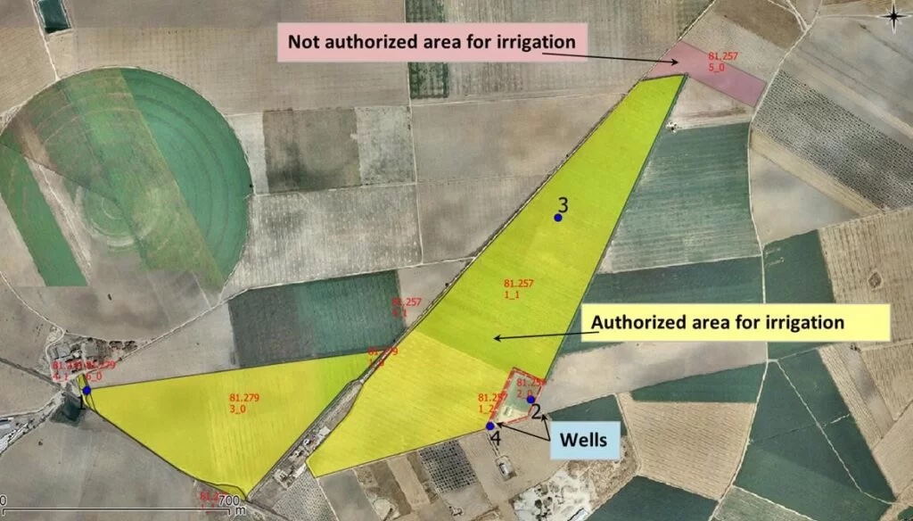
Remote sensing-based tools effectively control illegal water use in La Mancha Oriental, Spain, where strict rules regulate irrigation water use. However, with increased droughts and changing climate, irrigation non-compliance has become a severe issue. These techniques help locate irrigated areas without concession and excesses of the authorised volume.
The ERMOT and DIANA projects have provided water managers with robust, remote sensing-based tools to locate potential defaulters. The geographic information system shared between water users and the Júcar Hydrographic Confederation provides the areas with irrigation authorisation. Remote sensing allows farmers to obtain information about the quantity, quality, and development of vegetation in a plot, which can be used to estimate water consumption and ensure compliance with authorised volumes.
The control system's effectiveness has allowed non-compliance with the rules to be low. The volume of illegal irrigation water used represents less than 1% of all uses in La Mancha Oriental. Control of non-compliance with the rules for using irrigation water is essential to avoid overexploitation of water bodies. The information provided by earth observation is inexpensive and highly effective in controlling water use.
Conclusion
While earth observation is frequently associated with precision agriculture, its applications extend beyond this realm. As seen in the case study of La Mancha Oriental, remote sensing-based tools can effectively detect irrigation non-compliance, helping to control illegal water uses and avoid overexploitation of water bodies. The use of earth observation for water management and precision irrigation has the potential to significantly impact the agricultural sector and help ensure the sustainable use of natural resources. As technology advances, the applications of earth observation in agriculture and beyond will only continue to expand.
This project has received funding from European Union's Horizon 2020 research and innovation programme under grant agreement No 870518
