Drones in Crop Monitoring and Management: Uses, Types, Advantages and Limitations
Co-authors: Mr. Yash Vardhan Singh and Ms. Kriti Sharma
In the face of escalating global challenges in agriculture, such as rising food demand, environmental concerns, and diminishing resources, the integration of innovative technologies has become imperative. This article explores the transformative impact of drone technology as part of smart farming and precision agriculture.
The integration of novel technologies has emerged as a promising strategy to increase crop production sustainably, giving rise to concepts such as smart farming (Brewster et al., 2017; Tang et al., 2021) and precision agriculture (Khanna & Kaur, 2019).
Smart farming broadly refers to the incorporation of information communication technologies (ICT) and cutting-edge innovations into farming activities to enhance efficiency and efficacy (Haque et al., 2021).
Precision agriculture, on the other hand, focuses on site-specific management, where the land is partitioned into homogeneous segments receiving precise agricultural inputs to optimize crop yield through innovative technologies (Khanna & Kaur, 2019).
Technological advancements gaining scholarly attention in these domains include:
- Wireless Sensor Networks (WSNs) (Zheng & Yang, 2018),
- the Internet of Things (IoT) (Gill et al., 2017),
- artificial intelligence (AI) techniques, such as machine learning and deep learning (Liakos et al., 2018),
- computing technologies and big data (Gill et al., 2017)
In addition to the technologies above, remote sensing, particularly through satellites, human-crewed aircraft, and drones, has been recognized as a powerful tool to enhance smart and precision agriculture (Tsouros et al., 2019). Drones, also known as Unmanned Aerial Vehicles (UAVs), Unmanned Aircraft Systems (UAS), or remotely piloted aircraft, hold significance due to their distinct advantages over other remote-sensing technologies. For instance, drones can capture high-quality and high-resolution images even on cloudy days. Moreover, their accessibility and rapid data transfer contribute to their effectiveness. Compared to traditional aircraft, drones are highly cost-efficient and easy to deploy and maintain (Tsouros et al., 2019).
Initially developed for military purposes, drones have found diverse civilian applications, including:
- supply chain management
- humanitarian aid
- smart agriculture
- surveying and mapping
- cultural heritage documentation
- disaster management
- forest and wildlife conservation
Within agriculture, drones exhibit versatile applications when integrated with novel technologies, computing capabilities, and onboard sensors. These applications span crop management (e.g., mapping, monitoring, irrigation, plant diagnosis) (Huang et al., 2021), disaster reduction, early warning systems, and wildlife and forestry conservation, among others (Negash et al., 2019).
Types of Drones Used in Agriculture:
Drones used in agriculture vary widely in size, capabilities, and applications, catering to the diverse needs of modern farming practices.
- Fixed-Wing Drones:
- Size: Larger and airplane-like in structure.
- Capabilities: Known for covering large agricultural expanses efficiently, fixed-wing drones are suitable for mapping and surveying.
- Applications: Commonly used for large-scale crop monitoring, terrain mapping, and generating high-resolution orthomosaics.
- Advantages: Efficient coverage of vast areas, longer flight times, and the ability to carry advanced sensors.
- Limitations: Limited maneuverability, typically requiring more space for take-off and landing.
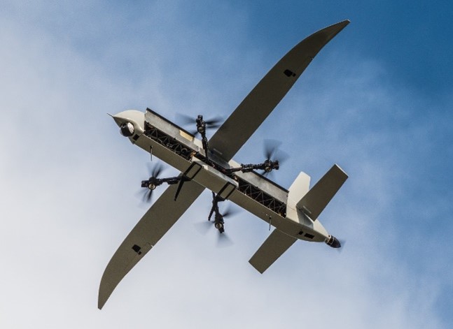
Fig.1- Fixed-Wing Drones
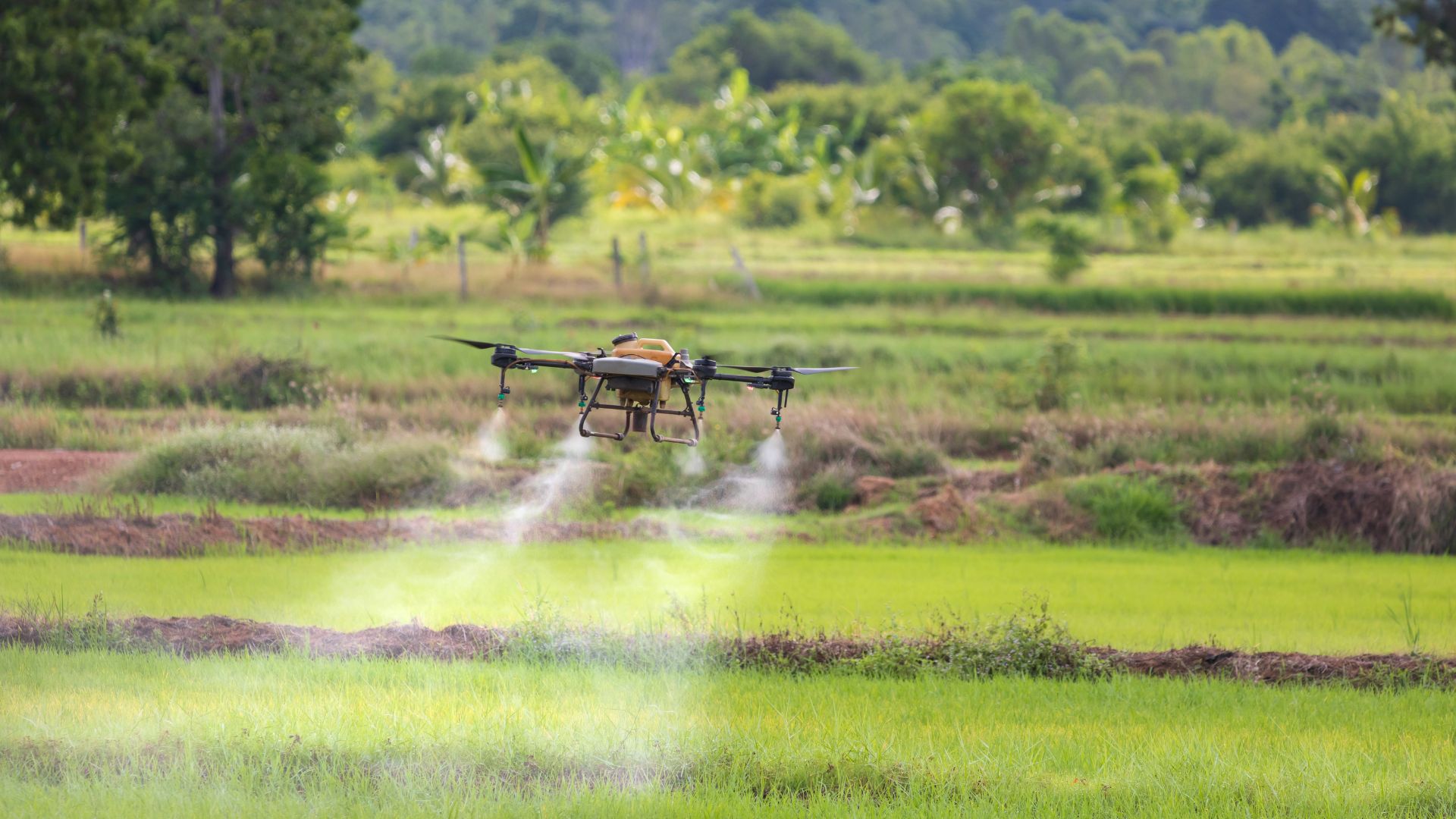
- Multirotor Drones:
- Size: Compact with multiple rotors (quadcopters, hexacopters, octocopters).
- Capabilities: Versatile and adaptable, multirotor drones excel in precision tasks and close-quarters operations.
- Applications: Ideal for tasks such as crop inspection, monitoring, and applying targeted treatments.
- Advantages: Vertical take-off and landing, hovering capability, ease of operation in confined spaces.
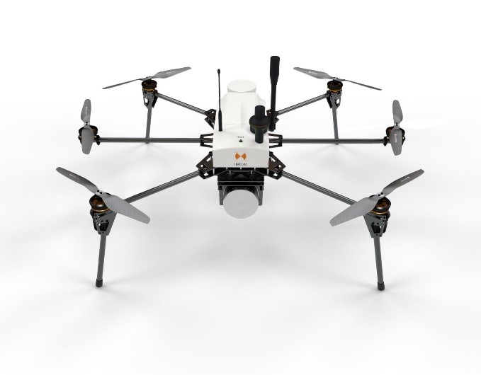
Fig.2- Multirotor Drones
- Limitations: Shorter flight times reduced coverage compared to fixed-wing counterparts.
- Hybrid Drones:
- Size: Medium to large, combining features of fixed-wing and multirotor designs.
- Capabilities: Blend the efficiency of fixed-wing flight with the flexibility of multirotor vertical take-off and landing.
- Applications: Suited for tasks requiring both extensive coverage and precision, such as varied crop monitoring.
- Advantages: Versatility, efficient coverage, and adaptability to different agricultural scenarios.
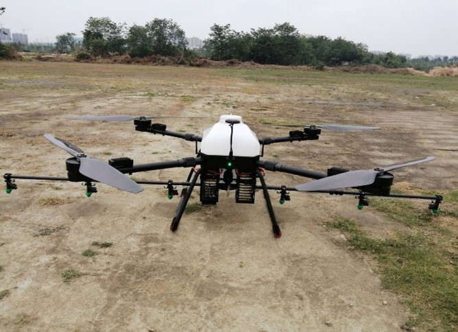 Fig.3- Hybrid Drones
- Limitations: More complex mechanics and potentially higher costs.
- Helicopter Drones:
- Size: Compact to medium-sized, resembling traditional helicopters.
- Capabilities: Offer a balance between fixed-wing efficiency and multirotor precision, with vertical take-off.
- Applications: Suitable for tasks like crop monitoring, mapping, and applying treatments.
- Advantages: Vertical take-off, landing capabilities, and adaptability for various agricultural applications.
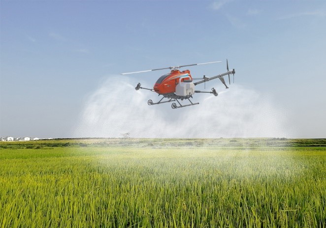
Fig.4- Helicopter Drones
- Limitations: Typically, shorter flight times compared to fixed-wing drones.
- Single-Rotor Drones:
- Size: Larger drones with a single rotor and a tail rotor.
- Capabilities: Efficient in carrying heavy payloads and covering large areas.
- Applications: Used for tasks such as large-scale mapping, surveying, and crop analysis.
- Advantages: Long flight times, ability to carry advanced sensors, and efficiency in covering extensive agricultural landscapes.
- Limitations: Complexity in design, higher costs, and the need for skilled operators.
Applications of Drones in Agriculture:
Crop Monitoring and Management:
Drones play a pivotal role in revolutionizing crop monitoring and management through their ability to capture high-resolution images and multispectral data. Equipped with sensors such as the Normalized Difference Vegetation Index (NDVI), drones provide real-time insights into crop health by detecting variations in plant vigor. This allows farmers to identify issues like nutrient deficiencies, pest infestations, and diseases at an early stage. Advanced imaging technologies, including thermal and hyperspectral cameras, further enhance the precision of crop health assessments. By routinely surveying large agricultural fields, drones empower farmers to make informed decisions, optimize interventions, and maximize overall crop yield.
2.1 Irrigation and Water Management:
Drones have emerged as key assets in monitoring and managing water resources in agriculture. Equipped with thermal and multispectral cameras, drones can assess the moisture levels in soil and identify areas of over-irrigation or water stress. This real-time data allows farmers to make informed decisions about irrigation scheduling, ensuring that water is applied precisely where and when it is needed. The impact on water-use efficiency is substantial, as drones help prevent wastage by optimizing irrigation practices. By incorporating this technology, farmers can conserve water, reduce operational costs, and contribute to sustainable water management practices.
2.2 Crop Spraying (Weed-Pest-Disease management with drones):
Drones have transformed crop spraying by providing a more precise and targeted approach compared to traditional methods. With the ability to fly at low altitudes and navigate through fields, drones equipped with spraying systems can deliver pesticides, fertilizers, or other treatments with unparalleled accuracy. This targeted application minimizes the risk of overuse, reduces environmental impact, and optimizes resource utilization. The advantages over traditional methods include increased efficiency, reduced chemical usage, and the ability to access challenging terrains that might be impractical for traditional machinery.
Crop Yield Estimation:
Drones contribute significantly to accurate crop yield estimation through their ability to capture high-resolution imagery and collect data on crop health and growth parameters. The data collected, including plant height, canopy cover, and vegetation indices, is processed through advanced analytics and machine learning algorithms. This enables farmers to predict crop yields with precision, aiding in strategic decision-making related to harvest planning, storage, and marketing. The role of data analytics in this process is paramount, as it not only enhances accuracy in yield prediction but also allows farmers to adapt their practices for continuous improvement in subsequent growing seasons. The integration of drones in crop yield estimation exemplifies their potential as essential tools for sustainable and efficient agriculture (Dong et al., 2019).
Technological Components of Agricultural Drones – What equipment does an agricultural drone carry?
Agricultural drones, designed for precision farming and crop management, are equipped with a range of advanced technological components that enhance their capabilities for data collection, analysis, and decision-making (Bareth et al., 2015).
- Sensors:
Sensors form the backbone of agricultural drones, allowing them to capture and interpret critical data about the environment and crops. Various types of sensors are integrated into drones for diverse applications. Notable examples include:
- Multispectral Sensors: These sensors capture data across multiple bands of the electromagnetic spectrum, enabling precise monitoring of crop health by detecting variations in plant reflectance.
- Thermal Infrared Sensors: Used for assessing temperature differentials, thermal sensors help identify stress in crops, pinpointing areas affected by diseases or inadequate irrigation.
- LiDAR (Light Detection and Ranging): LiDAR sensors provide detailed 3D mapping of terrain and vegetation, aiding in topographic analysis and precision agriculture applications.
- GPS (Global Positioning System): GPS sensors facilitate accurate georeferencing, allowing drones to navigate and collect data with high spatial precision.
- Cameras:
Drones are equipped with various types of cameras to capture visual and multispectral imagery, providing valuable insights into crop health and environmental conditions. These cameras include:
- RGB Cameras: Traditional cameras capture high-resolution images in red, green, and blue wavelengths, enabling visual inspection of crops and fields.
- Hyperspectral Cameras: These cameras capture a broad range of wavelengths, allowing for detailed spectral analysis and identification of specific crop conditions.
- NDVI Cameras: Normalized Difference Vegetation Index cameras quantify the health of vegetation by measuring the reflectance of near-infrared and visible light.
- GPS Systems:
GPS systems are integral to agricultural drones for precise navigation, mapping, and data georeferencing. The accuracy of GPS technology ensures that data collected by drones is correctly positioned within a specific geographic context. This is crucial for generating accurate maps, monitoring crop health, and facilitating targeted interventions in precision agriculture.
- Data Processing:
Data processing is a critical component of agricultural drone technology, involving analyzing and interpreting the vast amounts of data collected during flights.
Key aspects of data processing include:
- Onboard Processing: Some drones are equipped with onboard processors that analyze data in real-time, allowing for immediate decision-making during flights.
- Cloud-Based Processing: Collected data is often transmitted to cloud-based platforms for more extensive and sophisticated analysis. Cloud-based processing facilitates the generation of detailed maps, indices, and actionable insights.
- Data Integration: The integration of data from various sensors and sources, coupled with advanced analytics and machine learning algorithms, enables comprehensive analysis for crop health assessment, yield prediction, and resource optimization.
The seamless integration of these technological components empowers agricultural drones to provide farmers with actionable information, facilitating precision agriculture practices and contributing to more efficient and sustainable farming.
Challenges and Limitations of Implementing Drone Technology in Agriculture:
- Regulatory Challenges:
- Airspace Regulations: Strict regulations and restrictions on drone usage in airspace pose challenges for widespread adoption in agriculture. Integration with existing aviation rules and safety standards is a complex process.
- Privacy Concerns: Privacy issues related to data collection, especially when drones capture images of private property, have raised concerns among the public and policymakers.
- Cost Barriers:
- Initial Investment: The upfront cost of acquiring agricultural drones and associated technologies can be prohibitive for small-scale farmers. This includes the cost of the drone itself, sensors, cameras, and data processing tools.
- Maintenance and Training: Ongoing maintenance costs and the need for specialized training further contribute to the financial burden on farmers.
- Technology Limitations:
- Battery Life: Limited battery life constrains the flight time of drones, reducing their operational efficiency. Extended flight times are crucial for covering large agricultural areas.
- Payload Capacity: The payload capacity of drones limits the types and number of sensors that can be carried, affecting the diversity of data that can be collected during a single flight.
- Weather Dependency: Adverse weather conditions, such as strong winds and heavy rain, can impact the performance and safety of drone operations.
Future Trends in Drone Technology for Agriculture:
- Advancements in Sensor Technologies:
- Miniaturization: Continued miniaturization of sensors will allow for more lightweight and compact drone payloads, enhancing maneuverability and extending flight times.
- Integration of Advanced Sensors: Integrating increasingly advanced sensors, including hyper-spectral and LiDAR, will provide more detailed and accurate data for crop monitoring and analysis.
- Regulatory Developments:
- Standardization: Efforts to standardize regulations for drone operations in agriculture will facilitate smoother integration into existing farming practices and encourage wider adoption.
- Privacy Frameworks: The development of comprehensive privacy frameworks will address concerns related to data collection and use, fostering greater public acceptance.
- Cost Reduction Strategies:
- Economies of Scale: As demand increases, economies of scale in manufacturing and technology development are likely to lead to cost reductions, making drone technology more accessible to a broader range of farmers.
- Open-Source Solutions: The emergence of open-source platforms and technologies may provide cost-effective alternatives for farmers, allowing them to customize and adapt drone systems to their specific needs.
- Autonomous and AI-Driven Operations:
- Autonomous Flight: Advancements in autonomous flight capabilities will enhance operational efficiency by reducing the need for manual piloting, enabling drones to cover larger areas more effectively.
- Artificial Intelligence Integration: Increased integration of AI algorithms will enable drones to process data in real-time, improving decision-making capabilities and providing actionable insights on the spot.
- Combination with other Technologies:
- Integration with IoT: Collaborations between drone technology and the Internet of Things (IoT) will enhance data connectivity, allowing for seamless integration with other smart farming technologies.
- Blockchain Applications: The use of blockchain technology may contribute to transparent and secure data management, addressing concerns related to data integrity and trust.
As technology continues to evolve and stakeholders address current challenges, the future of drone technology in agriculture holds great promise. Integrating emerging trends is expected to propel drones towards becoming indispensable tools for sustainable and efficient farming practices.
References
Ajayi, O. G., Salubi, A. A., Angbas, A. F., & Odigure, M. G. (2017). Generation of accurate digital elevation models from UAV acquired low percentage overlapping images. International journal of remote sensing, 38(8-10), 3113-3134.
Bacco, M., Berton, A., Ferro, E., Gennaro, C., Gotta, A., Matteoli, S., … & Zanella, A. (2018). Smart farming: Opportunities, challenges and technology enablers. 2018 IoT Vertical and Topical Summit on Agriculture-Tuscany (IOT Tuscany), 1-6.
Bareth, G., Aasen, H., Bendig, J., Gnyp, M. L., Bolten, A., Jung, A., … & Soukkamäki, J. (2015). low-weight and UAV-based hyperspectral full-frame cameras for monitor-ing crops: spectral comparison with portable spectroradiometer measure-ments. Unmanned aerial vehicles (UAVs) for multi-temporal crop surface modelling, 103, (10.1127).
Brewster, C., Roussaki, I., Kalatzis, N., Doolin, K., & Ellis, K. (2017). IoT in agriculture: Designing a Europe-wide large-scale pilot. IEEE communications magazine, 55(9), 26-33.
Dong, T., Shang, J., Liu, J., Qian, B., Jing, Q., Ma, B., … & Wilson, J. (2019). Using RapidEye imagery to identify within-field variability of crop growth and yield in Ontario, Canada. Precision Agriculture, 20, 1231-1250.
Friha, O., Ferrag, M. A., Shu, L., Maglaras, L., & Wang, X. (2021). Internet of things for the future of smart agriculture: A comprehensive survey of emerging technologies. IEEE/CAA Journal of Automatica Sinica, 8(4), 718-752.
Gill, S. S., Chana, I., & Buyya, R. (2017). IoT based agriculture as a cloud and big data service: the beginning of digital India. Journal of Organizational and End User Computing (JOEUC), 29(4), 1-23.
Haque, A., Islam, N., Samrat, N. H., Dey, S., & Ray, B. (2021). Smart farming through responsible leadership in Bangladesh: possibilities, opportunities, and beyond. Sustainability, 13(8), 4511.
Huang, H., Yang, A., Tang, Y., Zhuang, J., Hou, C., Tan, Z., … & Luo, S. (2021). Deep color calibration for UAV imagery in crop monitoring using semantic style transfer with local to global attention. International Journal of Applied Earth Observation and Geoinformation, 104, 102590.
Khanna, A., & Kaur, S. (2019). Evolution of Internet of Things (IoT) and its significant impact in the field of Precision Agriculture. Computers and electronics in agriculture, 157, 218-231.
Negash, L., Kim, H. Y., & Choi, H. L. (2019, November). Emerging UAV applications in agriculture. In 2019 7th International Conference on Robot Intelligence Technology and Applications (RiTA) (pp. 254-257). IEEE.
Tang, Y., Dananjayan, S., Hou, C., Guo, Q., Luo, S., & He, Y. (2021). A survey on the 5G network and its impact on agriculture: Challenges and opportunities. Computers and Electronics in Agriculture, 180, 105895.
Tsouros, D. C., Bibi, S., & Sarigiannidis, P. G. (2019). A review on UAV-based applications for precision agriculture. Information, 10(11), 349.
Tzounis, A., Katsoulas, N., Bartzanas, T., & Kittas, C. (2017). Internet of Things in agriculture, recent advances and future challenges. Biosystems engineering, 164, 31-48.
Zheng, J., & Yang, W. (2018). Design of a Precision Agriculture Leakage Seeding System Based on Wireless Sensors. International Journal of Online Engineering, 14(5).
Co-authors (information)
Mr. Yash Vardhan Singh has completed his Masters in Soil Science from Maharana Pratap University of Agriculture and Technology, Udaipur, Rajasthan, securing the highest percentage in the Department of Soil Science & Agriculture Chemistry (2022). He has authored more than 10 research papers published in renowned national and international journals, along with numerous popular articles and book chapters. He has actively participated in more than 8 international and national conferences and training programs.
Ms. Kriti Sharma is currently pursuing her Ph.D. in Soil Science at MPUAT, Udaipur, Rajasthan. She completed her M.Sc. in Soil Science from MPUAT, Udaipur, Rajasthan, securing the University Gold Medal (2022). She has been awarded the DST-INSPIRE Fellowship (2023) by the Ministry of Science and Technology for her ongoing Ph.D. She received the Zonal Award (West Zone) (2023) from the ISSS, New Delhi, at the IISS, Bhopal (M.P.) for Best M.Sc. Dissertation. She has actively participated in more than 10 international and national conferences and training programs. Ms. Sharma has authored more than 12 research papers published in renowned national and international journals.